
Dr. Jim Delle, Senior Archaeologist and Regional Principal-East Coast, and his wife, Dr. Mary Ann Levine, Lewis Audenreid Professor of History and Archaeology at Franklin & Marshall College, authored a chapter in the recently published book, “Grappling with Monuments of Oppression”.
In the chapter titled “Catharine’s Town and the 1779 Sullivan Expedition against the Haudenosaunee”, Delle and Levine, grapple with the reality that the landscape of the United States is littered with historical markers “erected to celebrate what can best be described as colonial conquest.”
They write that, “the United States emerged and expanded as a settler-colonialist state, whose erstwhile heroes were often the perpetrators of what we would today characterize as ethnic cleansing, genocide, and war crimes. Events and related actors that were once considered formative or heroic in the epic of American expansion were celebrated in their day with monuments erected to the memories of their achievements. Unlike a commemorative speech or pageant that dissolves into air at its conclusion, historical monuments often remain on the landscape for generations, perpetuating the narratives of the victors of conquest.”
The 1779 Sullivan Expedition
“The Sullivan Expedition, a genocidal, scorched-earth campaign undertaken by the American Continental army in the late summer of 1779, is among the most widely memorialized events of the Revolutionary War,” Delle and Levine write. “Launched on direct orders from George Washington, the goal of the expedition was ‘the total destruction and devastation’ of Haudenosaunee settlements and ‘to ruin their crops now in the ground and prevent their planting more’. The resulting campaign stretched from Easton, Pennsylvania, in the east, to Geneseo, New York, in the west. The undertaking effectively expanded the theater of operations beyond territory claimed by any of the colonies by invading the homeland of the Haudenosaunee Confederacy. An estimated 40 villages were burned, incalculable numbers of cornfields and fruit orchards were destroyed, and thousands of people were either temporarily or permanently displaced.”
According to the couple, “On September 1, having looted and destroyed several small settlements between Newtown and Seneca Lake, the main body of Sullivan’s army was ordered to march to Catharine’s Town in the hope of catching the retreating Indigenous and British combatants. Following Washington’s orders, on September 2, Sullivan set his men to destroying the orchards, burning any remaining houses, and cutting and burning the corn and other crops still in the fields.”
Catharine’s Town: A Case Study in Historical Markers
Delle and Levine are intimately familiar with the current town of Montour Falls, as well as the former Catharine’s Town, on whose ruins it rests. They took many trips to the area to document the region while writing their chapter.
“Standing at the corner of Clinton Street and North Catharine Street in the town of Montour Falls, New York, it is hard not to reflect on the legacy of the events of early September 1779. The town of Montour Falls, constructed on the ruins of Catharine’s Town, took its name from Catharine Montour, a member of a much celebrated family of multilingual and intercultural mediators who were of both French and Indigenous descent. The memory of ‘Queen’ Catharine Montour is deeply incorporated into local identity in the now predominantly white town of Montour Falls,” they write.
The couple cites specifically 35 granite monoliths with bronze plaques, including one for Catharine’s Town, raised by the government of New York to commemorate the sesquicentennial of the 1779 Sullivan Expedition.
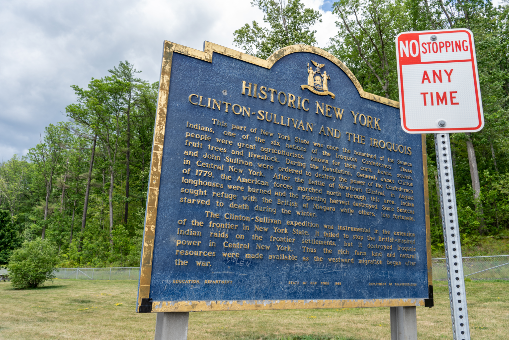
“In addition to the stone monuments that celebrated the 150th anniversary of the expedition, New York State erected a series of road sign markers commemorating the path taken by Sullivan, and the Haudenosaunee towns that were destroyed,” they write.
These road side markers and monuments are just a few of the many examples of historical markers erected by various organizations to commemorate this specific instance of scorched earth colonialism and genocide.
Violence Through Silence
Problematic historical markers identified, Delle and Levine examine the cost of such commemoration.
Citing one of the aforementioned bronze plaques, the couple notes a relief map featured on the plaque that “locates modern towns with their names (e.g. Montour Falls, Watkins Glen, and Ithaca). The locations of ‘Indian Towns and campsites’ are indicated by stars. Although the names of many of these places were recorded by Sullivan’s officers in their journals, none are named on this relief map.”
They write that, “the decision to represent post-Sullivan towns by name while ignoring the known place names of the Seneca Towns that were destroyed is itself a choice of violence through silencing. There is no indication on the plaque that these towns were intentionally destroyed, and it subtly twists the historical narrative of Sullivan to reinforce an inaccurate story of replacement of Indigenous people by whites.”
The couple also mentions a Daughters of the American Revolution (DAR) marker that suggests the purpose of the 1779 Sullivan Expedition was the severing of ties between Indigenous peoples and their English allies, and “completely ignores or disregards Washington’s strategic goal of ethnic cleansing of the Haudenosaunee.”
The text of the plaque reads:
“ROUTE BETWEEN LAKES
SULLIVAN EXPEDITION
1779
THIS CAMPAIGN
SEVERED THE
ENGLISH-INDIAN ALLIANCE
AND
CHECKED ENGLISH
AGGRESSION ON OUR
WESTERN FRONTIER.”
Ways to Right Historic Wrongs
According to Delle and Levine, actions are now being taken to tell the whole story of the 1779 Sullivan Expedition through interpretive signage.
At Lafayette College, in Easton, Pennsylvania, discussions are being had about the fate of a DAR marker on campus that commemorates the starting point of the expedition. Students have proposed a series of mitigation options, including:
- The removal of the plaque
- Its replacement with a statement recognizing the violence enacted on the Haudenosaunee people
- The installation of companion signage updating the message without removing the historical marker
The couple adds that “the reframing of the narrative on the Sullivan Expedition has also been taken up by the government of the town of Cooperstown, New York. A new historical sign erected near the site of Clinton’s encampment at Otsego Lake provides a more nuanced memorial of the Sullivan Expedition. This sign observes that the campaign was launched on Washington’s orders and that it destroyed 40 Haudenosaunee towns and laid waste to crops. This new memorialization of the event depicts a Haudenosaunee man with two women and three children, in stark contrast to the portraits of Sullivan and Clinton seen on the New York State monoliths. In doing so, and in expressing the Haudenosaunee name for Washington, which translates to ‘he destroys towns,’ this marker attempts to center the Haudenosaunee in the narrative.
Perhaps most importantly, Delle and Levine write that “the Haudenosaunee themselves are disrupting the replacement narrative that was inscribed on the 35 granite monoliths with bronze plaques and emblazoned on the associated metal roadside markers.”
Haudenosaunee cultural centers have emphasized their peoples’ survivance as opposed to their replacement.
“In so doing, the Haudenosaunee are narrating their own story,” they write.