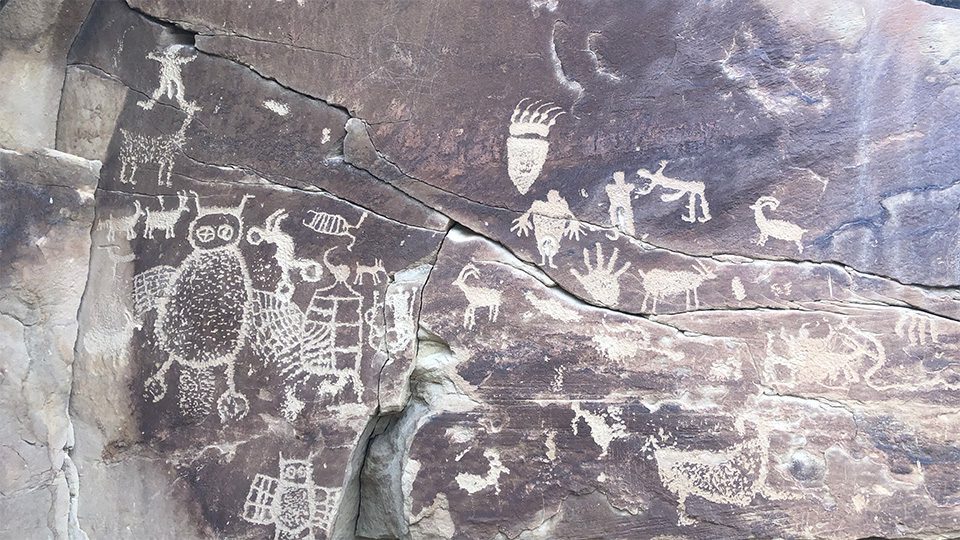
On the western edge of the Tavaputs Plateau, Nine Mile Canyon is one of the most exciting archaeological areas in the United States. As a natural transportation corridor, Nine Mile Canyon has provided seamless passage from the Uinta Basin into the Price River Valley for the past 9,000 years.
Preserved within the canyon’s jagged exterior lies an attraction that has captivated tourists and archaeologists for decades. Commonly referred to as “the world’s longest art gallery”, Nine Mile Canyon has the largest concentration of prehistoric rock art in North America. The famous “Great Hunt Panel” is one of an estimated 10,000 individual images to don its walls.
Our Mission
Preserving this art is of paramount importance to PaleoWest. During the fall of 2020, we began work for the Bureau of Land Management (BLM) on their Travel Routes project, a massive undertaking with the goal of documenting roads and off highway vehicle trails within the greater Nine Mile Canyon area and creating a baseline of all the associated cultural materials within proximity to these routes.
PaleoWest was selected for this project after a competitive bidding process due to our regional expertise, senior staff qualifications, ability to quickly mobilize, and our all-digital documentation approach – The PaleoWay. In Utah, the month of May is celebrated as Archaeology and Historic Preservation Month, and PaleoWest participated in the festivities by hosting a public archaeology and technology showcase event in Nine Mile Canyon.


Deploying Advanced Drone Technology
It has been over 30 years since some of these sites were originally recorded, so PaleoWest revisited these sites and used state-of-the-art technology to overcome the challenges the Canyon’s terrain presented. Innovative drone technology was of paramount importance to the project’s success, as it allowed us to expand and enhance the data collection process.
As part of the site recording, PaleoWest drones created a flight path over a distinct interval system and built a geo-referenced plan view map of the Daddy Canyon Complex, gathering precise new information to help analyze the site’s collection of rock art panels.

Our Team
Our talented public education and outreach team was led by Project Manager and Marketing Coordinator, Jamie Hollingsworth, and Project Manager Autumn Cool. As friendly tech wizards, they were able to fully harness and demonstrate the technology to visitors and gather breath-taking, never-before-seen footage of the Canyon.

Climbing High to Unlock The Granary and its Hidden Past
Researchers first documented the presence of a granary in 1972, alongside an accompanying Ladder arrangement and two rock art panels at an unnamed site.
Deploying the drone granted PaleoWest unique access to the granary, 20 feet above the canyon floor. The new vantage point of the structure allowed the team to analyze prehistoric construction techniques and revealed previously undiscovered seed remains. The team also conducted a search to identify any additional ladder fragments or storage structures on ledges directly above the granary itself. No evidence was found to suggest that additional prehistoric elements were present.


Prehistoric Rock Art, Frozen in Time
The project also presented our team with an opportunity to examine a series of 40 petroglyph and pictograph rock art panels within the Daddy Canyon Complex. Originally recorded in 1991, PaleoWest’s drone facilitated an updated recording of each rock panel’s GPS coordinates, identifying their location with pinpoint accuracy while producing detailed photographs and sketches of the art. Autumn Cool is currently patching together data clusters from the drone scans in order to create a spatially accurate, three-dimensional model of the site that can be used by the BLM for management or training purposes.
Interestingly, items originally recorded as graffiti in 1969 are now considered historic components of the site. This is due to the fact that anything over 50 years old is considered historic, and that threshold is constantly changing as time passes. The current cut-off is 1970. However, modern graffiti (< five years in age) was also documented by the team, and this is regarded as damage. The vital new information collected by PaleoWest provides an invaluable reference point for the BLM, guiding future decisions regarding on-site visitorship.

Hunting Alongside Our Ancestors with Atlatls
This ancient hunting technology is associated with the Archaic Period, around 2000-6000 years ago. Preceding bow and arrow technology, an Atlatl allowed hunters to throw spears further and faster.
Atlatls are known to have been used across the United States at the time, with evidence confirming their existence found throughout Nine Mile Canyon. Challenging weapons to handle and maneuver, the Canyon’s hands-on Atlatl visitor experience allows the public to appreciate and marvel at the exceptional skill of the period’s hunters.

The Importance of Preservation
Reflecting on their experience at the Daddy Canyon complex and the other unnamed site, our team is honored to have played their part in helping uncover the untold stories of Nine Mile Canyon. We would also like to say a special thank you to The Utah Division of State History, The Bureau of Land Management, and The Nine Mile Canyon Coalition for their support throughout the project.
At PaleoWest, we are eager to continue improving archaeological techniques with technological advancements that will help preserve heritage sites across the United States. However, it is important to remember that we can all play a role in maintaining sites such as Nine Mile Canyon. Capturing unique moments in time, their artifacts hold the secrets to events that have shaped the world as we know it.
Follow the link below to learn more about the exciting history of Nine Mile Canyon:https://www.visitutah.com/articles/the-46-miles-of-nine-mile-canyon
Alternatively, to discover how PaleoWest’s exciting technologies could support your business, visit https://www.paleowest.com/technology/

